ENTERPRISE GEOSPATIAL OPERATING PLATFORM · PRODUCTION READY
SPATIAL INTELLIGENCE · LIVE FIELD RADAR · MISSION COMMAND

The all-seeing spatial eye for every fleet, team, and field mission.

Whether you lead city sanitation, corporate transport pools, emergency rescue operations, or forestry ranger patrols — MYMAAN unites your spatial data, live GPS tracking, and offline mobile apps into one single command lens.

LIVE OPERATIONS RADAR
Waste Bins Monitored 1,482 Bins 100% on Map
Waste Trucks on Road 28 Trucks Voice Guided
Cleaning Completed 94.6% Done Photo Verified
Dedicated Website Open Waste OS wm.mymaan.com
Field Tested Active in Real Cities
Real-Time GPS Live on the Map
Photo Proof Before & After Photos
Works Offline No Internet Needed

TWO PRODUCTION MODULES ACTIVE NOW

Two live platforms ready for immediate deployment.

Both platforms are active today with live web portals, 30-day free pilots, and complete offline driver apps. Choose your platform:

wm.mymaan.com · ACTIVE NOW

Municipal Solid Waste OS

Built for city sanitation departments, municipal corporations, and waste contractors to keep streets clean and verify daily work.

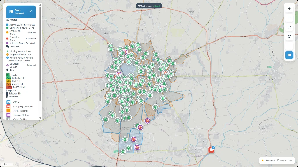
  • Smart Bin Map: See every waste bin location and scheduled collection point clearly on the map.
  • Cleaning Routes: Guide trucks along assigned streets in order with instant alerts for skipped bins.
  • Offline Driver App: Simple turn-by-turn voice directions on any budget Android phone without internet.
  • Photo Proof: Drivers take quick before-and-after photos to prove each bin was completely cleaned.
  • Clear Daily Reports: Automated logs of kilometers driven, tons collected, and fuel used.
Bin Map Offline App Photo Proof Fuel Reports
fleet.mymaan.com · ACTIVE NOW

Fleet & Mobility OS

Built for government departments, transport pools, and company fleets to manage official vehicles, bookings, and drivers.

  • Online Vehicle Booking: Officers request trips online with quick supervisor approvals from phone or PC.
  • Safety Inspections: A quick 2-minute mobile checklist to ensure the car is safe before driving.
  • Driver Trip App: Live status updates (Started, On The Way, Completed) with live GPS directions.
  • Odometer Photos: Quick photos of the dashboard meter before and after verify exact trip distance.
  • Trip Replay: Replay any past trip like a video on the map to see the exact route, stops, and speeds.
Safety Checks Odometer Photos Online Booking Trip Replay
LIVE COMMAND CENTER PREVIEW

See your entire operation live on one screen.

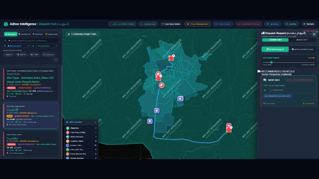
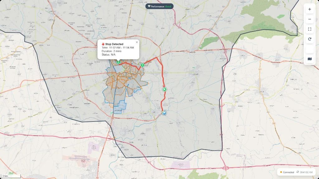
Experience the live command screens used by municipal teams and fleet depots. Switch views below to see real vehicle routes, waste bin locations, and live supervisor updates.

TRUCKS ACTIVE • STOPS VERIFIED
Mission Route Tracking and Stop Duration Auditing
Follow routes in order from start to finish
Automatic stop time tracking at each location
Live GPS path proves work and stops fake mileage

Frontline Mobile Apps

Simple mobile apps for drivers and supervisors.

Works on any basic Android smartphone. Runs smoothly in narrow streets, basements, and remote areas even with weak or no cellular signal.

WORKS 100% OFFLINE

Driver Mobile App

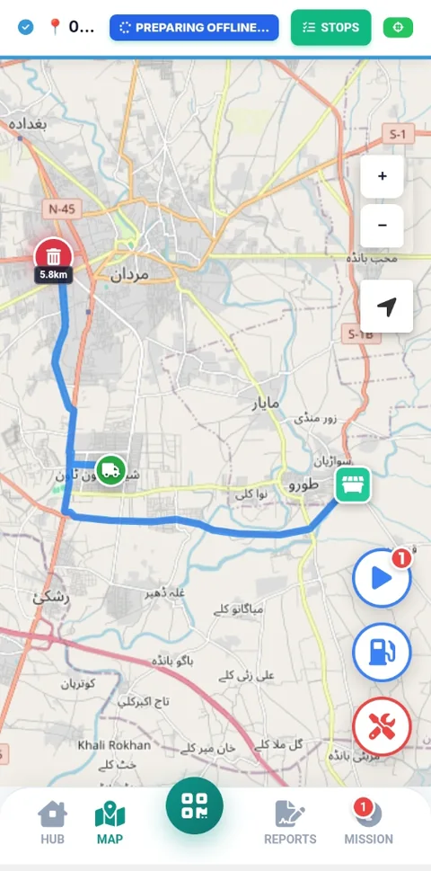
Clean, easy-to-read screen with voice directions in Urdu and English, step-by-step stops, and quick photo proof.

  • Clear turn-by-turn route directions
  • Saves all trip data safely on the phone without internet
  • Live camera with automatic date, time, and GPS stamp
Learn More
Driver Offline PWA Navigation Interface
LIVE GPS MAP

Field Supervisor App

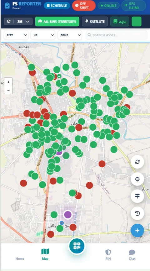
See all vehicles moving on the map, track neighborhood cleaning progress, and message drivers with one tap.

  • Live GPS map of all active trucks and vehicles
  • Neighborhood and ward completion percentages
  • Quick alerts, driver calls, and voice messages
Learn More
Field Supervisor Mobile Radar Application

Universal Spatial Intelligence

One powerful vision across every sector.

Municipal Waste OS and Enterprise Fleet OS are active and production-ready today. Rescue, Forestry, and Utility solutions share the same underlying geospatial engine and are available as custom enterprise rollouts on request.

ACTIVE MODULE

Municipalities & City Sanitation

"This is for me if I manage city cleaning, waste collection, or urban civic services."

Track waste compactors live, monitor smart bin fill levels, guide drivers along streets with turn-by-turn navigation, and verify bin clearance with tamper-proof before/after photos.

ACTIVE MODULE

Enterprise & Transport Fleets

"This is for me if I manage company vehicles, motor pools, or executive transport."

Move from paper requisitions to digital officer bookings, supervisor approvals, daily 2-minute safety walkaround checks, dual odometer photo audits, and video-like trip replay.

ROADMAP / ON REQUEST

Emergency Services & Rapid Rescue

"This is for me if I coordinate rescue teams, ambulances, or rapid responders."

Gain instant birds-eye awareness with live unit telemetry, rapid incident dispatch, real-time perimeter radar, and instant voice communication to frontline teams during critical missions.

Powered by MYMAAN Spatial Core · Available on Custom Request
ROADMAP / ON REQUEST

Forestry, Wildlife & Parks

"This is for me if I protect forests, monitor wildlife reserves, or manage park rangers."

Keep remote patrols connected with 100% offline trail GPS, boundary geofences, ranger patrol logging, and instant photo-verified incident reporting across vast terrain.

Powered by MYMAAN Offline GIS Core · Available on Custom Request
ROADMAP / ON REQUEST

Water, Pipelines & Public Utilities

"This is for me if I oversee water networks, pipeline leaks, or public infrastructure."

Overlay utility maps, water pipelines, and treatment facilities. Dispatch field maintenance crews to exact geographic coordinates with verified photo proof of repairs.

Powered by MYMAAN Asset Vector Engine · Available on Custom Request

Live Map Intelligence

See your assets, service zones, routes, and active vehicles clearly on high-resolution interactive maps.

Real Field Accountability

Structured mobile tasks, status milestones, and camera proof help frontline teams follow consistent daily processes.

Executive Reporting

Turn raw GPS coordinates and field logs into automated dashboards and clear reports for senior decision-makers.
Reliable & Secure System

Built for reliability, speed, and privacy.

Designed to handle hundreds of vehicles, field staff, and sensitive operational records safely.

Fast Spatial Maps

Accurate city boundaries, fast map loading, and precise location tracking.

Private & Secure Data

Your data is kept strictly private. Each company or department operates in its own secure space.

Works Without Internet

Phones save all trip points and photos locally, so weak signals never cause lost data.

Tamper-Proof Records

Stamped photos, verified odometer numbers, and unalterable trip histories ready for leadership audits.

Simple Pricing

Clear plans for teams of every size.

Start with an unrestricted 30-day pilot for your team, or choose a plan with official invoicing and support.

Free Trial

30-Day Free Pilot

Full access to test all features in your yard or fleet with your own team.

Free / 30 Days
Zero deposit or credit card required
  • Up to 10 Vehicles
  • Up to 25 Staff Accounts Included
  • Driver Offline Mobile App
  • Supervisor Live Radar Map
  • City Map & Waste Bin Setup
  • Private, Secure Company Account
Start 30-Day Free Pilot
Large Operations

Enterprise Custom

For regional development projects, public utility programs, and large operators.

Custom Enterprise
Custom setup with dedicated support engineer
  • 150 to 500+ Vehicles & Machinery
  • Unlimited Staff & Driver Accounts
  • Dedicated Private Server Setup
  • 24/7 Priority Support & Incident Help
  • Custom City Map Layers & Utilities
  • Custom Subdomain & WhatsApp Support
Contact Enterprise Team

Tailored For You

A system customized to how you work.

Tell us about your organization, city area, fleet size, and daily tasks. We will set up the best plan for you.

Got Questions?

Frequently Asked Questions

Quick answers to common questions about setting up and using MYMAAN.

Which modules are currently active and available to use today?
Currently, two core production operating systems are active and ready for immediate deployment: Municipal Solid Waste OS (wm.mymaan.com) and Enterprise Fleet OS (fleet.mymaan.com). Both feature instant 30-day free self-service pilots. Other specialized verticals (Emergency Services, Forestry & Parks, and Water & Public Utilities) are powered by the same underlying spatial engine and are available as custom enterprise rollouts on request.
Do we need to buy special GPS hardware boxes, or can drivers use smartphones?
You don't need any expensive GPS hardware. Drivers and field staff can use everyday budget Android smartphones. The phone's built-in GPS tracks vehicle locations, guides drivers along routes, and takes verified photos with no extra equipment needed.
How does the mobile app work in areas with poor or no internet?
The app downloads the day's route when the driver starts their shift. In areas with weak or no cellular signals, the app keeps giving turn-by-turn directions, saves trip points, and records photos locally on the phone. Once the phone reconnects to the internet, all data uploads automatically.
Can we manage different city zones, offices, or private contractors in one account?
Yes. MYMAAN lets you set up separate zones, yards, and contractor teams. Executive leaders get a single consolidated overview, while zone officers and contractor managers only see the vehicles, drivers, and routes assigned to their specific area.
How do photo checks prevent fake claims and verify work?
Photos must be taken live using the app camera — uploading old pictures from the phone gallery is blocked. Every photo is automatically stamped with the exact date, time, driver name, and GPS coordinates. For fleet trips, starting and ending odometer photos are verified against the GPS route.
How quickly can we start our 30-day free pilot?
You can sign up online in less than 5 minutes. If you already have map files or route lists for your city, our team can import them so your drivers can start using the system right away.

Get Started Today

Bring your operations into view.

See how MYMAAN can help your city cleaning, vehicle fleet, and field teams work smarter.